Rim Trail Loop
- Address: Sue-Meg State Park
- Trinidad, CA 95570
- Phone: (707) 677-3570
- Visit Website
The following hike is reproduced from The Hiker's hip pocket Guide to the Humboldt Coast by Bob Lorentzen, available from many local booksellers or directly from Bored Feet Press, www.boredfeet.com.
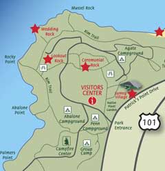
The Rim Trail follows an old Yurok path along the edge of the Patrick Point State Park's headlands. This easy, mostly level trail provides access to six steep spur trails that lead to promontories with breathtaking views. You can approach most of these spur trails by car but the Rim Trail provides an intimate look at the wild side of Patrick's Point.
The described trail begins at Agate Beach Trailhead and parking area, then circles the shore in a counter-clockwise direction. It circles back through the center of the park to your starting point. The trail is 3 1/8 miles long without any of the spur trails, 4 1/2 miles long if you take them all.
Head west from the parking area, descending along an obtrusive chain link fence. (The fence prevents foolish people from risking life and limb on the steep 200-foot bluff that drops to the ocean.) In 450 feet a wide spot provides an excellent view of Agate Beach. Sitka spruce rise above a dense understory of salal, blackberry, twinberry, ferns, angelica and azalea.
At 1/8 mile a spur trail meets the main trail. On your right is another fine view, with Mussel Rocks visible to the northwest and Agate Beach to the northeast. Red alders and shore pines join the forest as you dip through a small gully. Tall salmon-, elder- and thimbleberries shade the path where old apple trees also grow.
Enter dense forest again at 1/4 mile. Tiny Beaver Creek gurgles on your left. Soon you turn right toward the edge of the bluff and another overlook. The trail bends left, crossing a bridge above a waterfall at 3/8 mile. Pass through a dense tunnel of foliage and descend some steps to meet the Mussel Rocks trail on your right before 1/2 mile.
If you turn right, the path descends steeply to the rocks with a fantastic view of Agate Beach stretching north to Big Lagoon. It is 1/8 mile to the end of the spur, where you can fish or look. Climb 146 steps to return to the Rim Trail.
The Rim Trail climbs steps to level, then turns south. Pass between two big rocks, then descend stone steps to a convenient picnic spot.
Your trail heads west to another view of the coast. At 5/8 mile you pass another picnic spot (with a water spigot). As you approach the Wedding Rock parking area, take the first right fork to avoid the congestion at the popular day-use area. You soon meet the Wedding Rock spur trail.
The Wedding Rock spur descends rough steps, then climbs to the top of Wedding Rock at 1/8 mile. From the top of the 120-foot high ancient sea stack, you have a spectacular view of the coast to the south. This is also a great spot for whale watching and storm watching.
Returning to the Rim Trail, head south. You climb steps to join a paved, wheelchair-accessible path, then meet the Sue-Meg State Parkur trail at 3/4 mile.
The Patrick's Point trail branches right. The paved path descends to a picture-postcard view of Wedding Rock and the surrounding coast. The detour to Patrick's Point and back totals 1/4 mile.
The Rim Trail wraps around the base of Lookout Rock on your left to meet the Lookout Rock spur in just 150 feet. (It is 1/8 mile to the top of the ancient sea stack and back.)
Then the Rim Trail descends gradually through Sitka spruce forest. Descend steps to cross tiny Icky Ughie Creek, then climb to the Rocky Point side trail. (Turn right to walk down to Rocky Point, a 1/8 mile round trip).
Beyond the Rocky Point spur, the Rim Trail climbs a hill to meet a trail to the hike/bike camps then heads south through alder forest. The relatively open forest provides glimpses of the rugged coast. At one mile from the trailhead, a large cypress stands between the trail and the sea. You continue through forest and coastal scrub along the western edge of Abalone Campground. At 1 1/8 miles you meet the side trail to Abalone Point, where the Yurok tribe once had a seasonal village. (The steep spur descends to oceanside fishing and diving access--1/8 mile round trip.)
The Rim Trail turns southeast. Follow the wooded bluff, soon crossing a small bridge. At 1 3/8 miles you meet a paved trail from Abalone Campground. Turn right onto the paved trail and cross a bridge over Penn Creek, coming to the junction of three trails. On your left is the return path to the trailhead. The middle trail continues to the Campfire Center. Unless your time or energy is running short, take the right fork to one last magnificent viewpoint: Palmer's Point.
You follow Penn Creek to a bench and overlook, then veer left. Turn right at a junction. At 1 1/2 miles you cross a bridge over Beach Creek and head northwest. The trail passes through dense forest of Sitka spruce, shore pine and Bishop pine. The trail bed ends before 1 3/4 miles at the paved road to Palmer's Point. Walk the road shoulder for 1/8 mile to its end where a picnic area has a wonderful view up and down the coast. One spur trail leads west to the end of Palmer's Point. Another forks north to descend to rocky Cannonball Beach, a popular tidepooling spot.
Now retrace your steps back to Penn Creek bridge. Do not cross the bridge, but instead take the trail that leads east, heading upstream with the creek on your left. Soon you cross a paved road. At 2 3/8 miles you cross Penn Creek and come to a fork. Bear left to return to the trailhead.
The trail climbs gradually through dense spruce forest, turning north as it crosses six small bridges. You meet the park entrance road just east of the entrance station. Walk northwest on the road shoulder for 250 feet. Turn northeast before the entrance kiosk, passing the bookstore at 2 5/8 miles and taking the paved trail beyond the parking lot. In 150 feet veer left on a gravel path (the paved trail continues to Sumeg, the reconstructed Yurok village).
Descend north to cross a tiny creek and meet another fork at 2 7/8 miles. You can take the right fork to Park Headquarters, then walk the road back to your trailhead, or you may prefer to take the left fork. Veer left again at the trail to Ceremonial Rock. Take another left at an unmarked junction and walk 30 feet to a marked intersection at 2 7/8 miles. The left fork climbs to the top of Ceremonial Rock, a 3/8 mile round-trip. To return to the trailhead, take the right fork, marked Agate Beach Campground.
You come to coastal prairie, then cross a road. Descend to a bridge over Beaver Creek and ascend to a restroom in Agate Beach Campground. Go northeast on the campground road to return to the parking area at the trailhead.
Open Map
Close Map


